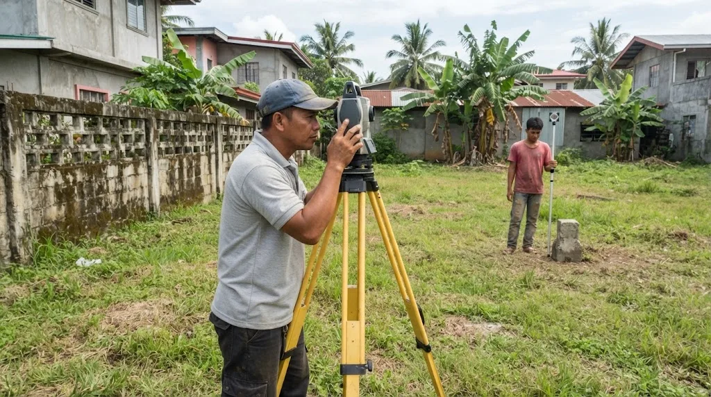
On the ground, your lot corners are marked by small concrete monuments like this one, and a relocation survey checks that they're in the right place. Illustrative photo.
Short answer: a relocation survey is a licensed geodetic engineer finding your lot's corners on the ground from the technical description on your title, and re-setting any monument (mohon) that's missing or has moved. Get one before you build a perimeter fence, before you put a wall close to the line, before you pay for a lot, and before you argue with a neighbour. It usually costs far less than moving a fence that turns out to be on someone else's land.
The checker below tells you whether your situation calls for one and what documents to bring. Further down, the encroachment calculator works out the strip a misplaced fence takes, and the lot area calculator checks the bearings and distances on your title before you pay anyone to lay out a house.
Your title doesn't show a drawing of the lot. It has a technical description: a starting tie point (often a government reference monument such as a BLLM), then a string of bearings and distances, "thence N 88 deg. 30' E, 15.00 m. to point 2" and so on, until the line closes back on corner 1. That description came from an approved survey plan made when the lot was first surveyed or subdivided.
In a relocation survey, the geodetic engineer:
A relocation survey doesn't change your lot, its area or your title. It shows where the lot you already own sits on the ground. If the fence, the neighbour's wall or your own house turn out not to match, that's a separate problem, covered further down.
This part is settled by statute. RA 8560, the Philippine Geodetic Engineering Act of 1998, defines the practice of geodetic engineering in Section 2(a) to include "land surveys to determine their metes and bounds", "boundary surveys" among engineering surveys, the "preparation and making of sketch, lot and location plans", and surveys "to determine and establish line and grade for the construction of buildings". Section 19 (kept in the RA 9200 amendment) says no person shall practice geodetic engineering without a license, and Section 20 requires plans to carry the geodetic engineer's seal.
So the contractor with a tape, the barangay tanod who "knows where the old fence was" and your civil engineer aren't the people to fix a boundary. That includes us. AEDO designs the house and the fence around the corners a geodetic engineer has verified, and we can coordinate with a licensed geodetic engineer for you, but the survey itself is his work and his seal.
You'll also need a geodetic engineer's work at permit time. Our building permit guide lists a lot plan signed and sealed by a geodetic engineer among the usual documents, alongside proof of ownership and the design plans.
Answer three questions and get a recommendation plus the documents to gather. It's a planning guide, not a legal opinion, and it can't tell you where your boundary is. Only the survey can.
| Document | Why it matters |
|---|---|
| Photocopy of the title (TCT or OCT), all pages | Has the technical description the survey follows. A recent certified true copy avoids surprises. |
| Latest tax declaration and tax receipt | Confirms the lot and owner on the assessor's records. |
| Approved survey plan or lot data computation, if you have it | Saves research time; otherwise the engineer has to find it. |
| Vicinity map or map pin, names of adjoining owners | Gets him to the right lot and lets the neighbours be told and invited. |
| Buying: seller's authority to sell, checked title | The survey checks the ground, not whether the seller can sell. |
People use these names loosely, so agree on the deliverable before you agree on the price.
On approvals: the original RA 8560 said plans of subdivided titled properties submitted by geodetic engineers "shall not be subject to verification and approval". RA 9200 (2003) amended that subparagraph and removed the phrase, so plans go to the government agencies concerned "using the numbering system and projection prescribed by the government". In practice that review is handled by DENR's land management offices, but we couldn't confirm the office names and steps from a DENR source, so let the geodetic engineer confirm them for your area. Our reading of these provisions: a relocation survey re-marks an existing plan, so it generally doesn't create a new plan for approval. That's an interpretation, not a ruling, so check it with the geodetic engineer.
There's no national fee schedule for relocation surveys that we could read and cite, and geodetic engineers set their own prices. What follows is an estimate, not a rate card.
| Situation | Typical fee | Basis |
|---|---|---|
| Residential lot up to about 500 sqm, 4 to 6 corners, town area, plan available | ₱15,000 – ₱35,000 | AEDO market estimate, 2026 |
| Larger or rural lot, more corners, far tie point, plan has to be researched | ₱35,000 and up | AEDO market estimate, 2026 |
| Subdivision survey with plan approval | Quoted per job; more than a relocation survey | Not estimated here |
The things that move the price are the number of corners, lot size and terrain, how far the tie point is, whether the old monuments survive, how much research the plan needs, travel, and how many printed copies you want. Get a written quote that says how many corners will be set, whether monuments are included, and what document you receive. Compare that with the cost of moving a fence: our CHB perimeter fence cost guide prices a solid fence per linear metre, and every metre of it is paid for twice if it has to come down.
After a survey shows your fence (or your neighbour's) off the true line, enter the length along the line and how far off the fence is at each end. The strip is treated as a trapezoid. Offsets come from the survey, not a guess.
This is where people panic, so here's what the Civil Code actually says. It's general information, not legal advice. Before you demolish, sign a deed or send a demand letter, talk to a lawyer.
Two practical points follow. First, if you commission a survey, find the fence is off, and build on anyway, it's hard to claim good faith afterwards. Second, time doesn't turn the strip into yours: PD 1529 Section 47 says no title to registered land "shall be acquired by prescription or adverse possession". An old fence isn't a boundary.
Most of these end in an agreement rather than a case: move the fence, or buy the strip through a proper subdivision and sale, which brings you back to the subdivision survey above. Encroachment can also stack with other neighbour issues such as eave drip and window distances, which our right of way and neighbour rules guide covers article by article.
Survey first, then design, then build. The cheapest order is: geodetic engineer verifies the corners, the engineer designs the fence footing and the house layout from those corners, and the contractor stakes out from the same monuments. Designing from a guessed line is how a footing ends up 30 cm into the neighbour's lot, and a boundary wall footing usually spreads wider than the wall above it.
A technical description should close: walk every bearing and distance from corner 1 and you should land back on corner 1. A small closing error is normal from rounding. A big one usually means a typo in your copy or a line left out, and it's worth knowing before the survey, not after. The calculator below also works out the area so you can compare it with the area printed on the title.
Paste the "thence" lines from your title's technical description, one per line, starting from corner 1, or switch to corner coordinates. It computes the area and how far the description misses closing. It doesn't adjust the traverse and it doesn't replace the geodetic engineer's computation.
Worked example (the tool's default): a lot described as N 88°30' E 15.00 m, N 01°30' W 20.00 m, S 88°30' W 15.00 m and S 01°30' E 20.02 m. The perimeter is 70.02 m, the description misses closing by 0.020 m, a relative precision of 1 : 3,501, and the area comes to 300.00 sqm, matching the 300 sqm on the title. If your copy of the title gives an area several percent off the computed one, or the closing error runs to metres, check your photocopy line by line and raise it with the geodetic engineer before the survey.
In Negros Oriental, AEDO designs and builds houses and perimeter fences, and we can coordinate with a licensed geodetic engineer so the survey happens before the layout. Outside the province, we provide the design and sealed plans and remote oversight of a contractor you hire locally; the survey is still done by a geodetic engineer near your lot.
What is a relocation survey?
A relocation survey finds and marks the corners of your lot on the ground using the technical description on your title and the approved survey plan behind it. The geodetic engineer starts from the tie point named in the description, runs the bearings and distances to each corner, checks any old monuments he finds, and re-sets the ones that are missing or have moved. It does not change your lot or its area. It shows you where the lot you already own actually sits.
Who can do a relocation survey in the Philippines?
A licensed geodetic engineer. RA 8560, the Philippine Geodetic Engineering Act of 1998, lists land surveys to determine metes and bounds and boundary surveys as part of the practice of geodetic engineering, and says no person shall practice geodetic engineering without a license. A civil engineer, architect, contractor or barangay official cannot fix your boundary for you, even if they own a tape measure and a copy of your title.
What documents do I need for a relocation survey?
Bring a photocopy of your title (TCT or OCT) showing the technical description, the latest tax declaration and tax receipt, the approved survey plan or lot data computation if you have one, and a vicinity map or pin of the lot with the names of the adjoining owners. If you are buying, add the seller's authority to sell and a title you have checked with the Register of Deeds. The geodetic engineer may ask for more, especially if the plan has to be researched.
How much does a relocation survey cost in the Philippines?
There is no published national rate, and geodetic engineers price it themselves. As an AEDO market estimate for 2026, a relocation survey of an ordinary residential lot of up to about 500 sqm with four to six corners in an accessible town area runs around ₱15,000 to ₱35,000. Bigger or rural lots, more corners, lost monuments, far tie points, research into old plans and extra copies push it higher. Get a written quote that lists how many corners will be set and what you receive at the end.
My fence turned out to be on my neighbour's lot. What happens now?
The Civil Code decides it by good or bad faith. Under Article 448, if you built in good faith, the neighbour can either keep the fence after paying the indemnity in Articles 546 and 548, or make you pay the price of the strip, unless the land is worth considerably more than the fence, in which case you pay reasonable rent. Under Article 450, a builder in bad faith can be made to demolish at his own cost. Article 453 treats both sides as in good faith if the neighbour also acted in bad faith, for example by watching the fence go up without objecting. Good faith is presumed under Article 527. This is general information, not legal advice; talk to a lawyer before demolishing or signing anything.
Does a relocation survey need DENR or LMS approval?
Approval is tied to survey plans, not to marking corners. PD 1529 Sections 50 and 58 require a subdivision plan to be approved before the Register of Deeds issues a title for part of a lot, and RA 9200 removed the old RA 8560 wording that exempted geodetic engineers' plans from verification and approval. As we read these provisions, a relocation survey re-marks the corners of a lot whose plan already exists, so it generally does not produce a new plan for registration. Splitting, consolidating or titling land does. Ask the geodetic engineer which case you are in and which DENR office handles it in your area.
Statute texts first, then AEDO's related guides. External links open in a new tab.
The relocation survey fee bands (₱15,000-35,000 for an ordinary residential lot, ₱35,000 and up for larger, rural or research-heavy jobs) are AEDO market estimates for 2026, not figures from a published fee schedule; geodetic engineers set their own fees and quotes vary widely. The survey checker's distance bands are AEDO planning judgment. DENR office names and approval steps for survey plans were not verified from a DENR source for this article (the Land Management Bureau site could not be reached) and should be confirmed with your geodetic engineer. Nothing here is legal advice.
Once a licensed geodetic engineer has marked the corners, AEDO designs the fence footing and the house layout from those same monuments, so setbacks, eaves and footings stay on your side of the line.