📚 Part of our Why Buildings Fail series →
Update, October 1, 2026: the toll has since risen well beyond the 29 August figures below. Nepal Police reported 1,127 dead and 4,858 missing as of 2 September, 05:00, with 911 unidentified bodies listed for family identification (The Kathmandu Post). We have not found a later official count, and the USGS page we cite stopped updating on 28 August.
The Government of Nepal's Ministry of Foreign Affairs reported 359 bodies recovered and 596 people from 33 countries missing as of 27 August 2026, 20:00 NST.2 Nepal Police and NDRRMA bulletins compiled at 29 August, 04:10 NPT put the toll at 553 dead and 1,924 missing in Nepal, with a further 554 missing on the Chinese side.3 These figures are rising as recovery continues and will date quickly — every number in this article is timestamped and sourced in the References. The Philippine DFA reports the Filipino community in Nepal accounted for, with the search continuing for one Filipino traveller.4
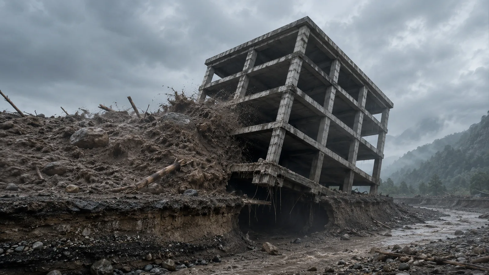
Illustration — not a photograph of the Nepal event. A commissioned engineering visualisation of the failure mechanism described in this article: the concrete frame stays intact while scour removes the bearing soil beneath the upstream footing, and the building rotates rather than crushes. | Illustration: AEDO Engineering
No earthquake. No typhoon. On an ordinary Wednesday morning, a wall of mud, rock and ice came down a Himalayan valley and carried away multi-storey reinforced concrete buildings — intact, upright, and whole.
That last detail is the one worth an engineer's attention. In the footage that circulated from the Nepal–China border crossing, the buildings do not crumble, buckle or pancake. They lean, slide, and go with the flow like furniture. Several of them were substantial concrete structures — the border customs and immigration facilities at Rasuwagadhi and the Gyirong Port crossing on the Chinese side, both reported destroyed.
Buildings that fail in an earthquake look nothing like this. Buildings that fail during construction — as in the Angeles City collapse this past May — look nothing like this either. What happened in Nepal is a different failure mode entirely, and it is one that no amount of extra rebar would have prevented.
This article explains the mechanics: what the forces actually were, why the concrete was never the weak link, and what the same physics means for Philippine sites — because we have no glaciers, but we have exactly this hazard.
On the morning of Wednesday, 26 August 2026, the USGS reports that a catastrophic debris flow and flood was "likely triggered by rapid slope failure involving a glacier" high in the Himalaya. The resulting flow travelled approximately 100 kilometres down the Bhote Koshi and Trishuli river system, across the Nepal–China border, affecting Rasuwa, Nuwakot, Dhading and Gorkha districts in Nepal and Gyirong County in Tibet.1,5
It is worth being precise about what is established versus what is still being worked out, because the difference changes how you read the hazard:
What the USGS actually says — and does not say
The USGS is explicit that the precise initiating mechanism remains open: "At this time, it is unclear if the initial slope failure was a landslide incorporating part of a glacier or a glacial collapse." It notes that the same mountain produced a debris avalanche in 2015 involving several million cubic metres of ice and debris, starting at around 5,000 m elevation. Widely repeated figures for the exact width, source altitude and drop height of the 2026 failure come from preliminary satellite analyses rather than from a completed official investigation — treat them as provisional.1
Two early explanations circulated widely, and both need qualifying:
It was not an earthquake
Seismometers registered a signal first reported in the press as a magnitude 4.4–5.2 earthquake. Per the USGS, the initial slope failure "generated energy equivalent to a M5.2 earthquake" — that is, the signal was produced by the failure, not by tectonic movement. A second seismic event equivalent to M4.2 was recorded roughly three hours later. Large landslides routinely produce seismic signatures that resemble small earthquakes, which is why early automated reports can mislabel them.1
It does not appear to be a classic glacial lake outburst
The Himalaya are known for GLOFs — glacial lake outburst floods, where a moraine dam impounding a meltwater lake fails. The USGS describes this event as a debris flow triggered by slope failure and does not classify it as a lake outburst; independent landslide analysis likewise reads the seismic and satellite evidence as a rock-ice avalanche and debris flow rather than a lake breach.1,5 On that reading the water most likely came from ice melted by the energy of the failure, water held in the entrained sediment, and the river itself. The distinction matters operationally: a glacial lake can be monitored, and sometimes drained, in advance. A slope that fails without warning cannot.
Casualty figures: Nepal Police as of 2 September 2026, 05:00, reported by The Kathmandu Post (earlier bulletin: 553 dead and 1,924 missing at 29 August, 04:10 NPT).3 Travel distance and seismic energy: USGS.1
Alongside the human toll, reporting compiled from Nepali authorities describes destruction of tens of kilometres of road and dozens of bridges, the Rasuwagadhi customs facility, the Gyirong Port border crossing, and damage to hydropower facilities along the Trishuli including Rasuwagadhi, Chilime, Trishuli 3A and 3B, Trishuli Station and Devighat.3,6 Rescuers spent days trying to reach people trapped inside a hydropower tunnel whose entrances had been buried in mud.6 Damage-count figures in circulation vary between sources and remain preliminary.
Before any of the engineering below: hundreds of people are dead and thousands are still missing. Among them are residents of Rasuwa and Nuwakot, workers at the border crossing and the hydropower stations, security personnel who were stationed in the valley, and travellers from more than thirty countries — including one Filipino still unaccounted for.2,4 Entire families and livelihoods were taken in minutes.
Everyone at AEDO Construction OPC extends our deepest sympathies to the people of Nepal and of China, to the families still waiting for news, and to the rescue teams working in conditions that have already cost some of them their own lives.
We have written this analysis because we believe the most useful thing engineers can offer after a disaster is a clear account of why it happened, so that the next community in a valley like this one is somewhere safer. That intent is not a substitute for grief, and nothing below is offered as commentary on the choices of the people who lived there. If you are able to help, the Government of Nepal's official disaster relief appeal is the appropriate channel.8
When a structural engineer looks at that footage, the striking thing is what is absent. There is no progressive collapse, no shear failure at the columns, no pancaking of floor plates. The buildings translate and rotate as rigid bodies.
That signature tells you the superstructure never governed. Three actions happen simultaneously, and the third one is usually decisive:
The lateral pressure a moving fluid exerts on an obstruction is given by the standard hydrodynamic drag expression — the same one behind flood-load provisions in ASCE 7 and the bridge-pier drag rules in Eurocode 1991-1-6:
Note where the velocity sits: it is squared. That single fact governs everything about this hazard. A flow that moves twice as fast does not hit twice as hard — it hits four times as hard. Between a 5 m/s flow and a 12 m/s flow there is a factor of nearly six.
Work a representative case: a debris flow 3 m deep hitting a building 10 m wide, at ρ = 2,000 kg/m³, Cd = 1.5, v = 8 m/s (a moderate speed for this kind of event).
For scale, compare that with the strongest lateral loading a Philippine building is normally designed for. In our NSCP 2015 wind load guide we work through a typical two-storey house at 6 m height at a 250 kph basic wind speed (NSCP 2015 Fig. 207A.5-1A contours run roughly 240–320 kph, highest along the eastern seaboard). The velocity pressure comes out around 1.8–2.0 kPa.
This is the honest answer to "why didn't they build it stronger?" You cannot detail your way out of a 48× overload. And even that understates it, because the drag force is only action ➊.
Models all four actions described above — steady drag, surge-front peak, debris damming and buoyancy — then runs the two stability checks ASCE 7-22 requires: sliding and overturning.
If drag alone were the whole story, you would expect to see walls punched in and frames racked over. You mostly do not. You see whole buildings leave.
That happens because a debris flow is simultaneously an excavator. Moving at those velocities against an erodible river terrace, it strips soil from around and beneath the foundations. A spread footing derives its entire capacity from the soil bearing beneath and the confinement around it. Remove that soil and the footing is holding nothing — no matter how much rebar is in it.
Once the upstream footings lose bearing while the downstream ones still have it, the building rotates. The moment arm is generous: the drag resultant acts near mid-depth of the flow, and the restoring moment depends only on the building's self-weight about a toe that is itself being washed away. Then the structure — still perfectly intact, still a competent frame — becomes a very large piece of debris.
You cannot economically design an ordinary building to survive a direct debris-flow strike. The loads are 1–2 orders of magnitude beyond normal design actions, and the foundation can be removed regardless of superstructure quality. Debris flows are managed by avoidance and by civil works — check dams, deflection berms, channel training — not by thickening columns. The decision that determines survival is made before any concrete is poured: where you build.
The 48× figure above is the sustained drag load. It is not the worst moment, and it is not the whole load case. Four further actions matter, and together they explain why the outcome is so consistently total.
The surge front hits harder than the flow behind it
Experimental work divides debris-flow impact into stages: the arrival of the flow head is a sudden impulsive strike, followed by a quasi-steady body phase. Measured peak impact pressure in the body stage was 0.68 ± 0.14 times that of the head — meaning the front arrives roughly one and a half times harder than the sustained flow.15 The drag equation describes the load after the front has passed. The first second is worse.
Buoyancy quietly deletes the building's weight
A building resists both sliding and overturning using its own weight. Immerse part of it in a fluid at twice the density of water and Archimedes takes much of that away. Take the same 10 m × 10 m footprint in a 3 m flow: if the ground storey resists inundation even briefly, the displaced volume is 300 m³, and the uplift is ρgV = 2,000 × 9.81 × 300 ≈ 5,890 kN — about 600 tonnes-force. A four-storey reinforced concrete building at roughly 11 kPa per floor over that footprint weighs on the order of 4,400 kN. The uplift can exceed the entire weight of the building.
Two consequences follow immediately. Base friction is μN — drive the normal force N toward zero and sliding resistance goes with it. And the restoring moment that resists overturning is a function of that same weight. This is also why flood-resistant design uses flood openings and breakaway walls: letting the flow through the ground storey collapses the displaced volume to just the structural members, and with it the uplift. A sealed ground floor is the worse option here, not the better one.16
Debris damming grows the area A
The building becomes a strainer. Logs, vehicles and boulders pile against the upstream face, and the obstructed area A grows well beyond the building's own silhouette. Because force scales linearly with A, a debris dam that doubles the blocked area doubles the force — and it does so while raising the flow depth locally, which raises it again. ASCE 7-22 added explicit design guidance on debris damming for exactly this reason.16
Two stability checks, not one
ASCE 7-22 requires global-stability load combinations for both sliding and overturning.16 Note what the preceding actions do to each. Sliding resistance depends on weight — buoyancy removes it. Overturning resistance depends on weight and on the position of the toe — buoyancy removes the first, scour removes the second, while drag and surge supply the driving moment. Every mechanism attacks the same two equations simultaneously. That is the real reason these buildings leave intact: not one overwhelming load, but the coordinated removal of everything that was holding them down.
Run the calculator above on our worked case with flood openings — a 10 × 10 m, four-storey building in a 3 m debris flow at 8 m/s — and it returns a sliding factor of safety of 0.61 against an overturning factor of safety of 4.07. In other words, on level ground and before any scour, the arithmetic says the building should slide long before it topples — and that is what the Rasuwa footage shows in its first moments: structures translating downstream, upright and intact. Add scour, which this calculator deliberately does not model, and the picture completes: once the upstream footings lose bearing while the downstream ones still have it, the rotation described earlier follows. Sliding starts it; scour finishes it. When a model built from first principles independently reproduces the observed sequence, it is reasonable to trust what it says about the cause. Seal that same ground storey and the result flips to net uplift — the buoyant force exceeds the building's entire self-weight, and both factors of safety fall to zero.
Bridges, hydropower intakes and border facilities cannot always be moved out of a valley. Where a structure must sit in a channel, the engineering answer is foundations carried below the anticipated scour depth — piles or caissons founded in material the flow cannot reach — combined with upstream civil works. ASCE 7 requires erosion and scour effects to be carried into the load calculation, taking the loss of soil as an increase in water depth and therefore an increase in the flood loads themselves.16 For an ordinary building on an ordinary budget, that is a far more expensive answer than choosing a different lot — which is the entire argument of this article.
It is worth putting this next to the Angeles City collapse of May 24, 2026, which we analysed in detail. At 3:00 AM a nine-storey reinforced concrete building came down on a perfectly ordinary site — no earthquake, no flood, no external load at all. Thirty people died. That was a pancake collapse: floor slabs losing vertical support and stacking sequentially, the signature of a structure that could not carry its own weight.
| Angeles City, May 2026 | Rasuwa, August 2026 | |
|---|---|---|
| Site | Benign — ordinary urban lot | Lethal — valley floor, debris-flow path |
| Structure | Deficient (under investigation) | Adequate for its design loads |
| Trigger load | Self-weight alone | ~50× design wind, plus scour |
| Failure mode | Pancake collapse — crushed in place | Rigid-body translation — carried away whole |
| Preventable by | Design review, inspection, QA/QC | Site selection and hazard mapping |
They are mirror images. Angeles was a good site with a bad building. Rasuwa was good buildings on a bad site. And yet the root cause is the same category of failure: a decision made on paper, before construction, that nobody adequately checked. In one case it was the structural design and the way it was built. In the other it was the choice to put a border facility, a hydropower station and a settlement on a valley floor that had a documented history of exactly this hazard.
Writing after this event, landslide researcher Dave Petley warned that "we systematically under-estimate the risk associated with these events" in the Himalaya.5 Substitute "in the Philippines" and the sentence holds just as well.
Nothing in the physics above depends on ice. What made the Nepal flow lethal was density, velocity, and volume — and rain produces all three here on a regular basis. The Philippine analogues are rain-triggered debris flows, post-eruption lahars, and landslide-dam breaches.
The reference case is Guinsaugon, Saint Bernard, Southern Leyte, 17 February 2006. The peer-reviewed analysis by Evans and colleagues in Natural Hazards and Earth System Sciences documents the failure of a 450 m high rock slope within the damage zone of the Philippine Fault, where the rock mass had been tectonically weakened by active strike-slip movement. The rockslide-debris avalanche involved a total volume of 15 million cubic metres including material entrained along its path, and ran out 3,800 m horizontally over an 810 m drop. Over 1,100 people perished when the village — directly in the path — was overwhelmed.7
Two findings from that paper deserve emphasis, because both cut against intuition:
A rockslide-debris avalanche of that kind is faster and more energetic than a typical channelised debris flow, so 35 m/s should be read as the severe end of the Philippine range rather than a routine design case. The point stands either way: this hazard is not a structural problem, and the Philippines has already lived through it.
The practical difference between Nepal in 2026 and a Philippine site in 2026 is that here, the hazard is already mapped, published, and free to check.
This is the part that converts a news story into something you can act on. Before you buy a lot or finalise a design, run these:
1. MGB geohazard maps (1:10,000, barangay level)
The Mines and Geosciences Bureau publishes landslide and flood susceptibility maps at 1:10,000 scale — detailed enough to resolve individual barangays. They are viewable and downloadable free through the MGB Geohazard Web Portal, and copies were distributed to LGUs as a reference for local development planning and disaster-resilience programmes.12 If your site plots as high or very high susceptibility, that is a finding you act on, not a formality.
2. HazardHunterPH — site-specific assessment
The government's GeoRisk Philippines platform generates a hazard assessment report for a specific coordinate, covering seismic, volcanic and hydrometeorological hazards together. It takes minutes and gives you something in writing to attach to a feasibility study.13
3. Water Code easement — the 3/20/40 rule
Article 51 of PD 1067, the Water Code of the Philippines, places the banks of rivers and streams under an easement of public use within a zone of 3 metres in urban areas, 20 metres in agricultural areas, and 40 metres in forest areas, and provides that no person shall be allowed to stay in that zone longer than necessary for recreation, navigation, floatage, fishing or salvage, "or to build structures of any kind."11 Read it as a legal minimum for public use, not an engineering safety margin — on an alluvial fan or a steep valley floor the hazard footprint routinely extends far beyond it.
4. Foundation investigation — NSCP 2015 Chapter 3
NSCP 2015 Sec 303.1 requires a foundation investigation and a professional report at every building site. For structures two storeys or higher, an exhaustive geotechnical study shall be performed, with a minimum number of boreholes set by footprint area (Table 303-1).14 Beyond bearing capacity, a proper investigation is where scour potential, liquefaction and slope stability get raised — see our guides on soil profile types and foundation types.
5. LGU zoning and the CLUP
Your local government's Comprehensive Land Use Plan and zoning ordinance encode local no-build zones and hazard overlays — and a locality that has been hit before usually knows exactly which barangays flood. Ask, and ask the neighbours too. Institutional memory of the last big event is often better than any map.
Land priced well below the surrounding market is usually priced that way for a reason, and the reason is often on a geohazard map. A ₱200,000 discount on a lot does not compensate for a total loss of the structure — and structures in an active flow path are frequently uninsurable or excluded from cover. Check the maps before you pay the reservation fee, not after.
What caused the August 2026 Nepal flood?
Per the USGS, a catastrophic debris flow on 26 August 2026 was likely triggered by rapid slope failure involving a glacier, and travelled about 100 km down the Bhote Koshi and Trishuli rivers. The USGS is explicit that it remains unclear whether the initial failure was a landslide incorporating part of a glacier or a glacial collapse. It was not a tectonic earthquake — the seismic signal was energy released by the failure itself, equivalent to M5.2, with a second M4.2-equivalent event about three hours later.1
Why do well-built concrete buildings get swept away instead of collapsing?
Three actions occur at once: hydrodynamic drag of roughly 40–200 kPa on the upstream face, concentrated impact from boulders and logs, and — usually decisive — scour of the bearing soil from under the footings. Once the foundation loses its soil, an intact frame simply rotates and is carried away as one rigid piece.
How is flood force on a building calculated?
F = ½ρCdAv². Because velocity is squared, doubling the flow speed quadruples the force. A 2,000 kg/m³ debris flow at 8 m/s gives about 96 kPa — roughly 48× the ~2 kPa design wind pressure for a typical two-storey Philippine house. Try the calculator above with your own numbers.
Can you design a house to survive a debris flow?
Not economically, and not reliably, if it sits in the direct path. The loads are one to two orders of magnitude beyond design actions and the foundation can be scoured away regardless. This hazard is managed by avoidance and by civil works — check dams, deflection berms, channelisation — not by strengthening individual houses.
Does the Philippines face the same hazard?
Yes. No glaciers, identical physics. In the peer-reviewed analysis of the 2006 Guinsaugon rockslide-debris avalanche in Southern Leyte, over 1,100 people died when the village was overwhelmed; the failure involved 15 Mm³, ran out 3,800 m, and was modelled at a mean velocity of 35 m/s. The study found no direct trigger — it followed heavy rainfall with a four-day lag.7 Lahars and typhoon-triggered debris flows produce the same dense, fast-moving mixtures.
How do I check whether a property is in a hazard zone?
Check the MGB 1:10,000 geohazard maps, run the site through HazardHunterPH, review your LGU's CLUP and zoning, and confirm the PD 1067 Article 51 easement (3 m urban / 20 m agricultural / 40 m forest). Then get a foundation investigation per NSCP 2015 Chapter 3 before finalising the design.
Where sources disagree, we have said so in the text rather than picking the most dramatic number. Casualty figures from an ongoing disaster are provisional by nature — each is given with the issuing body and a timestamp so readers can check it against the current official count. Engineering values for density, velocity and drag are representative published ranges used to illustrate the scale of the loads; they are not site-specific measurements of the 26 August 2026 event, and nothing here constitutes a design calculation for a specific structure.
Statutes, codes, official tools and references used or referred to in this article, linked to their source. Links open in a new tab.
Prices, cost bands and rate figures in this article are AEDO Construction's own market and practice figures for Philippine work unless a source is named beside them. Code and statute references above link to the primary text.
Site conditions govern more of a structure's fate than most owners realise. AEDO's engineers review geohazard exposure, drainage and waterway proximity, soil investigation requirements and foundation strategy as part of structural design — so problems surface on paper, where they are cheap to fix.